
We’d picked up a little brochure of local walks from Tourist Information in St-Florent, and this one was just up the road from the spectacular black and white church of San Michele de Murato. It was listed as Balade dans le Nebbiu (stroll in the fog). The Nebbio is the region of Corsica inland from St-Florent, a hinterland enclosed by an amphitheatre of hills, that takes its name from the heavy mists that descend in winter. Today was not sunny, but thankfully we were not enveloped in clouds.

We set out from the village of Rutali, and after one or two false starts we eventually found the right path, a beautiful green lane into the hills. Looking back through my photos from that day I found a huge collection of lush green images of ferns, blackberries, honeysuckle, lilac, sweet chestnut, wild clematis, as if every step I took was recorded with a click of the camera. Far too many pictures but this one stands out, a tree covered in flowering ivy, smelling sweet and humming, buzzing, vibrating with bees. It was a bee tree. And as we walked there were more and the bees were all around our heads.

For a moment it seemed we’d entered a deep green land of bees and honey.


A tree full of medlars.

Between threshing-floors and stonehouses


And finally a gate, an entrance to go walkabout, around a memorial circuit, un véritable parcours de la mémoire, a journey between ancient drystone houses and yards where wheat was once threshed and winnowed and ground beneath round stones driven in a circle by oxen. This place was once a hive of industry with many little mills scattered over the hillside. Now it’s a breath of fresh air.


Here, as in the whole of Nebbio, the “pagliaghju” owes the very particular structure of its corbelled vault to the schistose nature of the rock present at the site. The large flat slabs “e teghje” are obtained by cleavage. Corbelling is a very old technique, around 6,000 years. This simple technique is based on precise mathematical data.
From the upper edge of the interior wall, generally at shoulder height, the “teghje” are placed one on top of the other, gradually shifted towards the centre of the construction according to one rule: the centre of gravity of two consecutive stones should never go beyond the edge of the stone on which they are laid. The corbelled stones are not laid flat but inclined at an angle of about 15° to the horizontal plane. This promotes the self-locking of the stones located on the same plane. The corbelling that starts on a square or rectangular structure takes on a circular shape as it grows.
The residual opening is obscured by one or several very large flat stones. The overhang of the cantilever also receives a “teghje” cover which, in addition to its apparent roof function, serves as a counterweight to hold the whole structure together.

Stonehouse of Pianezzule.

Look inside and welcome the path…

a water-worn path…

with man-made steps…

and a handbuilt cairn…

with a speckled lizard guide waiting to show us the way.


Through the tunnel and our lizard wizard bid us farewell.

We entered a newfoundland between fern frond hands, their fingers enmeshed and inviting,

they conjured a cow, right here, right now, suddenly beside us, up close and surprising.

Funtana di Monique

Between fern frond fingers and forever

Between dancefloors and opera houses

Between fern floors and ivy houses


Between ferns and a floating walnut tree.


Pagliaghji, dry stone constructions, are characteristic of the Nebbiu region. In the commune of Rutali there are around a hundred. It owes the particular structure of its cantilever vaulting (false vault) to the schist nature of the rock present on the spot. The large “e teghje” slabs are obtained by cleavage. Corbelling is a very old architectural technique, around 6000 years old. It had several functions according to the times and the seasons: place of storage of the cereals, temporary habitat of the shepherds, shelter for the animals.


Aghja: These threshing floors are always near a pagliaghju. There are more than twenty of them in the Commune. Easily identifiable, the aghja is delimited by a circle of large flat and erect stones. A large round stone attached to the yoke of the oxen, rolls for hours on the cobs to ensure fulling (a tribbiera). After threshing comes winnowing (a spulera) where the fulling product is thrown in the air using a three-pronged wooden fork. The grain of the straw is then separated naturally by the evening breeze.


Marbled Bush Cricket (Eupholidoptera schmidtii)

Another threshing-floor and another stonehouse.


And follow the path down beneath ropes and loops and woody stems of overhanging vines.

A casetta di Ange

Ivy and sweet chestnut


To another Pagliaghju


and another Aghja with ox already installed.


There was a whole herd already in the ferns, bracken-ready wood pasture cows

and look close, there’s a calf, and a wary mother cow watching us pass.

We climbed the hill towards Monte Torricelle and looked down at the opposite coast from where we’d started, the distant Étang de Biguglia below Bastia, the flamingo lagoon on the east side of the island.


This stonehouse was the highest, and it was just at the point where we turned around to head back to where we’d started from. There was a small enclosure nearby, surrounded by a stone wall. I only later learned that it’s a cemetery for Moroccan soldiers killed in the Second World War.
I Pughjali: On September 28, 29 and 30, 1943, elements of the 1st battalion of the 1st regiment of Moroccan Tirailleurs, the Goumiers, guided by Rutalais and under the orders of Commander Soleilhavou, took up positions at a place called “I Pughjali” for dislodge the German troops occupying the Santu Stefanu pass below. The simultaneous battles of the Cols de Teghjme and Santu Stefanu liberated Corsica on October 4, 1943, which became the first French department to be liberated.
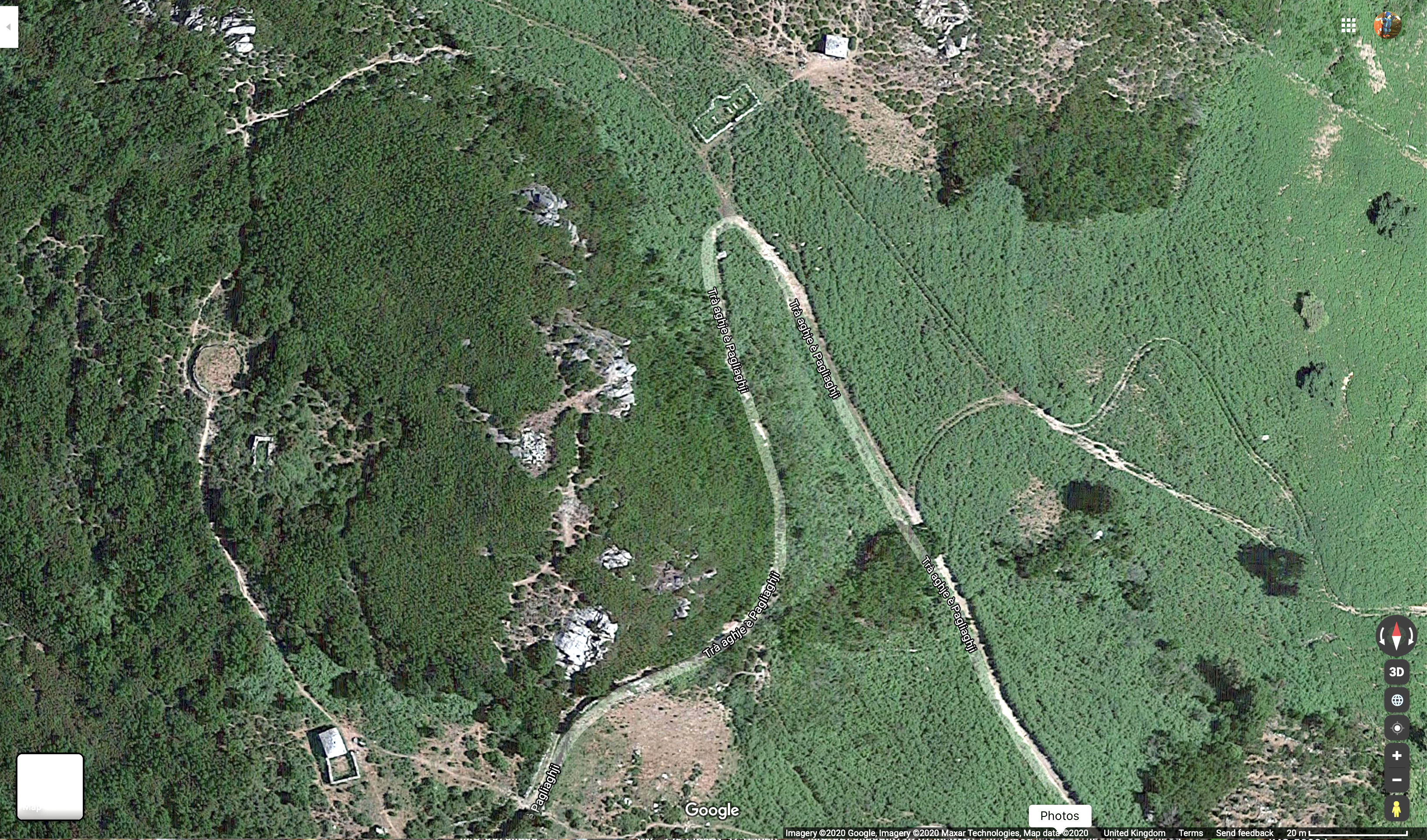
I didn’t get a photo but you can see it in this Google Maps satellite image, at the top of the picture, just above the turnaround of the path. Earlier, we’d spotted a collection of beehives off the side of the path.


Clearly visible in the satellite image, this must be where the bees we met at the ivy tree came from.


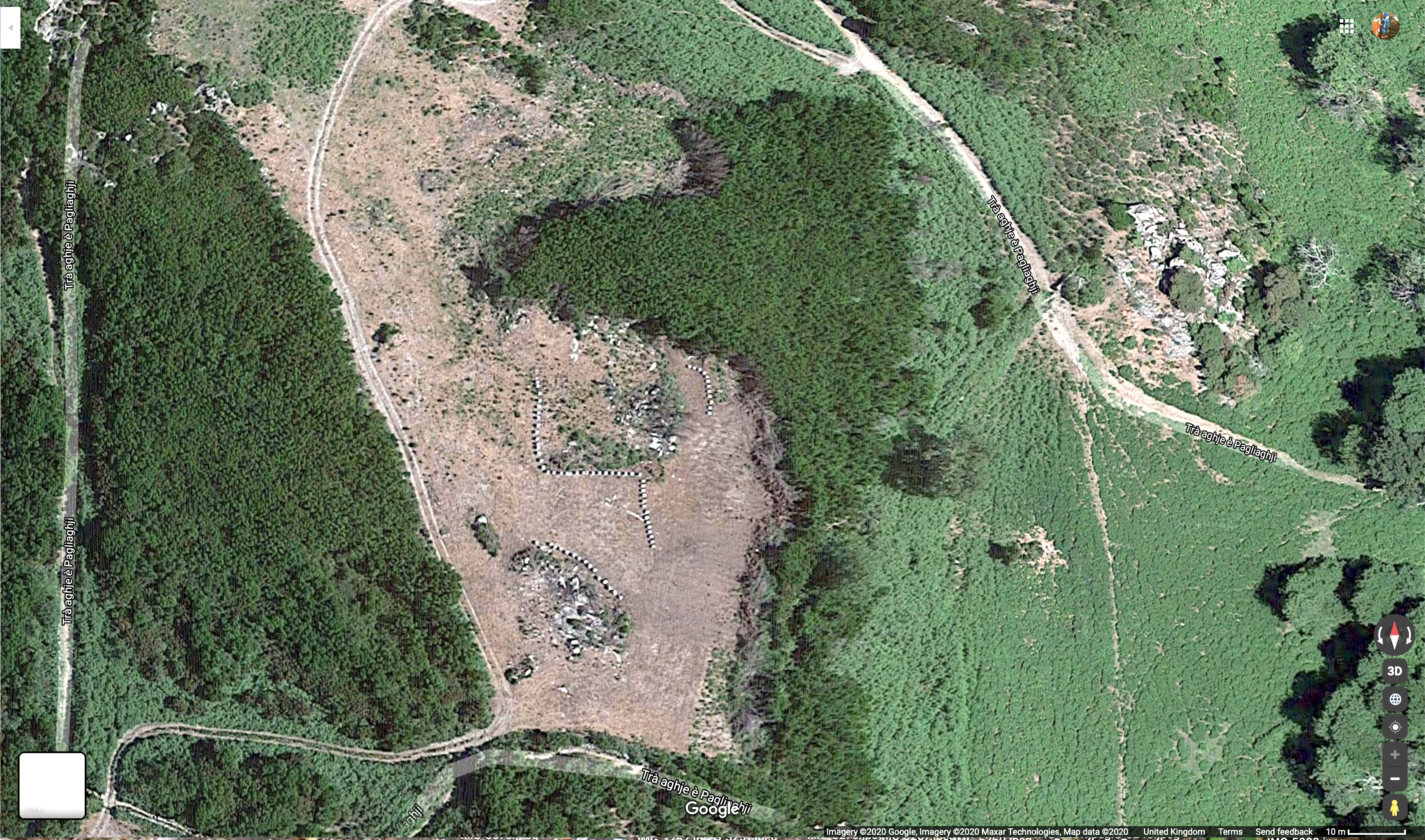
This final Pagliaghju can also be seen on the first satellite image above, clearly identifiable by its attached stone wall enclosure. The notice alongside tells how, after the First World War, when wheat was no longer grown here, sheep farming was introduced and this was a shepherd’s hut.

The gradual disappearance of wheat on the territory and the constant decline of the population after the war of 14-18 is accompanied by a concomitant increase in pastoralism.
Up to 5000 heads of cattle were counted, some testimonies speak of 10000, sheep, goats and to a lesser extent cows.
The establishment of Fromageries Roquefort in Corsica has favored this phenomenon. Certain Pagliaghji like this one, with their enclosure “chjostra” could also be used as sheepfolds, places of milking of animals and manufacture of cheeses.

Along the path behind the hut we found yet another Aghja.


And then from here it was a straight downhill run back to the entrance gate.


Bryony and bramble, ivy, hazel, walnut and fig.


※
One thought on “A Walk In The Nebbio”